Posted On: Monday - February 16th 2026 6:21PM MST
In Topics: General Stupidity Political Correctness Female Stupidity
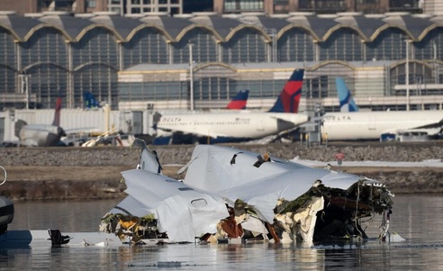
We’ll get to the D.I.E. factors tomorrow. The reader may want to read our recent post for links to what we posted a year ago, but I’ll put these 2 NTSB links again:
This very thorough NTSB report
The complete CVR Transcript
Now, I was off on the terminology earlier, but basically the report has 74 what they call Findings, followed by Probable Cause, which in this case were 2 most important, followed by 5 Contributing Factors. After that are 50 Recommendations.
Let me run through what these are about. The Findings contains basic checks on legalities, with plenty of things found to have been done per the book, along with many criticisms. Probable Cause has the most basic cause of the wreck, with many of the “shoulda’, coulda’” or wish list criticisms left behind. The Contributing Factors have some good points that combine many of the other of the 76 critical Findings into just a handful. Finally, Recommendations takes many of the criticisms and calls for the specific action that could fix these. The latter explains why one accident can cause a whole lot of changes, with a good share of them not really being necessary in hindsight.
The Findings points start off basic checks that the pilots were legally certified and properly qualified, that they were not fatigued and same for the crew of the helicopter and the Air Traffic Controllers involved. The staffing level of the tower was adequate (more on this), both aircraft were legal maintenance-wise - often more about paperwork than anything - and since this was a mid-air, and the remains of the aircraft confirmed what had happened (obviously), some kind of intensive check to unlock a mystery was not warranted. (They still look at a WHOLE LOT of items here, no matter.) Through the first 15 of the 74 Findings, everything was per the rules. From there, the Findings got more critical, pointing out things that could have been done better or should be done in the future.
There are a couple of non-critical items interspersed, such as #49, that, though there was no reason to believe the tower controllers had been drinking or on drugs, the drug testing was kind of behind. (Not everyone can just get a ride at the spur of the moment to go pee in a cup. MOAR and QUICKER peeing in cups! OK… )
#23, about a standard safety alert call-out, per some spec, was silly, IMO. The tower - by “tower”, in this case, I mean the one guy working the “local” position - did what he could. #27 says:
The PAT25 instructor pilot did not positively identify flight 5342 at the time of the initial traffic advisory despite his statement that he had the traffic in sight and his request for visual separation.This is in Probable Cause, as the 2nd point of 2, but to me, this is the gist of why anyone would have a reason to write about these 2 flights to begin with.. In fact, “did not positively identify” is being generous. From the transcript, providing voices from the front of the helicopter, there was no “positively” about it - neither of the pilots even bothered to identify anything.
I won’t get into all points here (same with the Recommendations that come out of them) in order not to write a 10ft long post. Here’s the Probable Cause:
We determined that the probable cause of this accident was the FAA’s placement of a helicopter route in close proximity to a runway approach path; their failure to regularly review and evaluate helicopter routes and available data, and their failure to act on recommendations to mitigate the risk of a midair collision near Ronald Reagan Washington National Airport; as well as the air traffic system’s overreliance on visual separation in order to promote efficient traffic flow without consideration for the limitations of the see-and-avoid concept.What’s in the 1st paragraph there is something I’ve argued about and I’ll argue till the cows come home - that route down the river can work fine, but not as an aircraft is landing on Runway 33 or, landing on or taking off of the opposite end, 15. (Landing too, because there may be a go-around, putting someone in that same spot.) The intention of the tower here was not to have any traffic there AT THE TIME due to PSA’s having agreed to swing around and land on it. In fact, the recommendations do not include shutting down that helo route, but only shutting it down if 15/33 is in use. It’s their first out of 50, this to the FAA:
Also causal was the lack of effective pilot-applied visual separation by the helicopter crew, which resulted in a midair collision. Additional causal factors were the tower team’s loss of situation awareness and degraded performance due to the high workload of the combined helicopter and local control positions and the absence of a risk assessment process to identify and mitigate real-time operational risk factors, which resulted in misprioritization of duties, inadequate traffic advisories, and the lack of safety alerts to both flight crews. Also causal was the Army’s failure to ensure pilots were aware of the effects of error tolerances on barometric altimeters in their helicopters, which resulted in the crew flying above the maximum published helicopter route altitude.
Prohibit operations on Helicopter Route 4 between Hains Point and the Wilson Bridge when runways 15 and 33 are being used for departures and arrivals, respectively, at Ronald Reagan Washington National Airport (DCA). (Urgent)Yes, and it probably went into effect that night, for good.
That’s one part of the argument, something that’s not within the DCA tower’s (that is, this time I mean the facility) immediate control. Wait, you say, just let them crash?* No. This will now lead back to the main points here. The tower (the guy) did nothing wrong - I don’t agree with the small points from the NTSB. (There was a point made that there was enough staffing to have one controller run the helo frequency**, but the supervisor didn’t decide that - or do it himself, perhaps. That wasn’t the real problem anyway, as I think things would have gone the same way. Why? Read on.)
When the Blackhawk chopper going by PAT***-25 was way up the river still, more than a minute before the collision, the tower told them - with both helo pilots listening but the instructor doing the talking, on the radio - to look for PSA 5342 (Call sign Bluestreak 5342), its type (CRJ-700) and that it was circling for Rwy 33. Finding #26, on the radio reception** in the helicopter, may seem like an important factor here, but no, they heard his transmission after they called out their position at the Memorial Bridge just north and replied. See the left column in the CVR transcripts at 20:46:01.6 for this. This is what went into the CVR either directly from the radio or out of a speaker through the air in the helo. (I’m guessing the 1st way is how it’s set up.)
We run into the problem that I’ve written about and mentioned here as Finding #30:
The absence of documented training on Ronald Reagan Washington National Airport’s fixed-wing procedures and the mixed-traffic operating environment represented a safety vulnerability for Army flight crews operating in the Ronald Reagan Washington National Airport Class B airspace.Right. These army people have got their routes shown on charts along with all the terrain/obstacles, whatever, but unless they are coming in or out of DCA itself, they may very well not know the layout of the airport! I think that was the case here. Did they know where Rwy 33 was situated, hence where the approach path would be?
6 seconds after the tower called out that specific Bluestreak traffic to Pat-25, the instructor pilot transmitted “Pat two five has the traffic in sight request visual separation”. This is the reason for the crash. There was no talk whatsoever - remember this CVR records all the talk - along the lines of “Do you see him?” “He must mean that one.” “You got em? I got ‘em.” This report does mention it, but the writer seems to think that the pilots in Pat-25 saw somebody they thought it was, even had the missed the tower’s “circling to 33” or didn’t know the airport layout. I blame the instructor for this one, as the other pilot was still his student and probably figured he knew what he was doing. It’s possible she thought this was perfectly cool too.
It’s NOT. If you are not sure which traffic, you ask again, or you say you don’t have it in sight. If one of the pilots thinks he has the right one, then he should point it out to the other to confirm. Even if not that, if he isn’t completely sure, he should say “not in sight”. How could he be so sure he had this specific CRJ in sight - the place was crawling with him. If he didn’t know where the path this place would take from the Wilson Bridge (called out by the controller) to line up and land on Rwy 33 - same thing - ask for more info or just transmit “we don’t have ‘em.”
This happened the 2nd time too, pretty late in the game, at 20:47:39.1, then 5s later the instructor again requested visual separation. I know they were busy in there, but WHY?? Again, there was no talk about which plane between these 2 pilots.
Here’s where I don’t blame the controller. It works like this. There’s a whole lot of trust built into the system. The assumption is there are all honest and competent people involved.
If the pilot on the radio says his aircraft will maintain “visual separation”, then he/the aircraft must do that. If you’ve got the right one, you do whatever you need to, and early is of course much better, to change flight path and/or altitude to stay clear. The controller is relieved of separation duties at that point. If you aren’t sure you easily can, then you don’t request it, or if asked to “maintain a visual once you have the right traffic in sight, you can still say “unable”. (I’m thinking of the night vision goggles and all the city lights as seen from that low.)
I’ll bring in one very minor doubt here. This is again about the pilot requesting to be allowed to maintain visual separation from the aircraft they both didn’t even look for. The tower could have refused.**** OTOH, one could rightly ask, why then even point out the traffic? That’s a good question for this situation. Sometimes it is done, in cruise flight for example, just for situational awareness, and time permitting. That night, the tower pointed Bluestreak 5342 out to help PAT-25 go where he wanted to go.
That brings up a second general thing about the ATC system. The pilots are generally the “customer”, as it were. These controllers, whether, in cruise flight, giving route shortcuts, relaying reports on turbulence and taking many requests for altitude changes for this reason, near the airport, approving requests for the runway closest to the terminal or other ramp, or giving more helpful taxi instructions, work to help aircraft get where they want to go the BEST ways. That is, of course, safety, i.e. separation, permitting. Could the tower have just realized, “I don’t like this, and “Hey, Pat-25, just hold at the Memorial Bridge. I’ll get you going in a couple of minutes.”
I’m guessing that tower controller is losing hours of sleep each night, thinking, I could have told him this, or that, or earlier… yes, tragic. Yet, had Pat-25 made AN EFFORT to either find the traffic or not blow the tower off (basically what the Instructor was doing - you can read the transcript) and just say “We don’t have him”, they would have heard pretty much the same “Pat-25, hold at the Memorial Bridge.” After all, this would have been so easy - it was a helicopter! They can basically stop. Were some small plane down there, he might hear an immediate “[Call sign], immediate right 180 degree turn and fly heading 350” - whatever.
To quit beating this dead horse, let me just say, regarding the argument about the use of the route to begin with, this traffic was only allowed on it at that point in time because of PAT-25’s “confirming” he saw Bluestreak 5342.
Another point, though is, this non-standard and dishonest behavior aside, an aircraft staying under 200 ft above the river (the same as “msl”, above mean sea level there) and even keeping to the left of the river would be TOO CLOSE to the approach path for Rwy 33.***** The normal “glide path” is 3 degrees. That works out to very nearly a 300 ft descent per nautical mile, ending 1,000 ft down the runway. At that east side of the river, with that angle, the CRJ would be a mile out and should have been at 300 ft up. So, the 200ft ceiling of this Route 4 corridor is always much too close for normal separation. About the barometric altimeters: I’d think they’d have radar altimeters, great for this phase of flight, on board these taxpayer-bought machines, but I don’t know. If you see the traffic, the altimeter reading wouldn’t matter.
If the reader peruses the voice transcripts, he might catch some talk within the helicopter, that is between the pilots. (I only twice saw an “INT-3:” note in the left column, which from that Crew Chief behind them. He said “clear left” twice as he did a good look for them as they turned. He was looking for tall cranes and such. You gotta watch it - I’m not claiming that all this is easy.) Besides that talk early on about Rebecca, the student, having about gone off the route completely, with some accompanying humor between them, the instructor told her a number of of times that she needed to come down and also get over to the left side of the river as they headed south. I am sure that wasn’t due to his seeing the traffic. He wanted to stay compliant with the rules. The way he told her wasn’t very forceful.
Now, finally, Contributing factors include:
The limitations of the traffic awareness and collision alerting systems on both aircraft, which precluded effective alerting of the impending collision to the flight crews;The 3rd and 5th points are, the way I see it, just calls to have lots more meetings. Safety Management Systems are virtual paperwork with input from pilots and others. That’s all good, but I want to deal with more concrete things. The 1st and 2nd are very important, and the 4th could have helped, but again they are “contributing factors”. The collision would not have happened if not for what’s written in the 1st paragraph and 1st sentence in the 2nd of Probable Cause.
An unsustainable airport arrival rate, increasing traffic volume with a changing fleet mix, and airline scheduling practices at DCA, which regularly strained the DCA ATCT workforce and degraded safety over time;
The Army’s lack of a fully implemented safety management system, which should have identified and addressed hazards associated with altitude exceedances on the Washington, DC, helicopter routes;
The FAA’s failure across multiple organizations to implement previous NTSB recommendations, including ADS-B In, and to follow and fully integrate its established safety management system, which should have led to several organizational and operational changes based on previously identified risks that were known to management; and
The absence of effective data sharing and analysis among the FAA, aircraft operators, and other relevant organizations.
That was a doozy! Next and hopefully final post on this subject: How good are the military vs the civilians, and was this crash D.I.E. related?
PS: I almost changed the whole post around based on a little helicopter-intercom call that’d I missed. At 20:42:43..2, just after the first time the PSA traffic is called out to them by the tower, the woman student says “I see it. To the left.” That wasn’t about the traffic but about the Chain Bridge that her instructor had just told her was next.
Then, too, a reader could be confused by the intercom talk half a minute earlier at 20:42:16.2. They were talking about the Blackhawk (or multiples of them) going by Blackhawk One. That aircraft or flight (more than one) was ahead of them. Their discussion was about his being on the same route or not. That was pretty good situational awareness there.
* Sorry, I shouldn’t be facetious here as this hits close to home, but it is one of hundreds of funny lines from the movie Airplane.
** In fact, one of the factors here was the crappy radio reception the army helicopter had. That’s not unusual at times. See Recommendation #42. The girl student even asked if the tower had a UHF frequency, which only the military uses. The instructor didn’t know and was probably too busy to look it up. They’d have better reception perhaps, but they’d still not hear the UHF calls on the normal (non-special-helocopter) frequency. One can tell, besides that last call to “pass behind” that was stepped on, that they got all the calls.
*** The PAT is a general call-sign for any military aircraft flying around the brass, which this flight was a practice run for (some major SHTF deal).
**** Way back in time, about 15 minutes before the collision (20:33:41.1) PAT-25 was approved for the route, “Cabin John”, just some odd name for it, but #1 to #4 on the way to Davidson. Why did the controller let him? There was no reason not to, and Bluestreak 5342 hadn’t even been asked to land on Rwy 33 and accepted yet. That was routine.
***** Even more of a worry and uncertainty would be the flight path of an airplane taking off from Rwy 15 or doing a go-around after attempting a landing on it.
******************************
[UPDATED 02/19:] As explained in this Wednesday’s post, the page I linked to for the full report I got all these excerpts from was changed. Thanks again, Adam Smith, for getting us to a web archived version. The link should again to to the right report.
******************************
Comments:
M
Tuesday - February 17th 2026 7:01AM MST
PS
"About the barometric altimeters: I’d think they’d have radar altimeters"
Minor point. From what I remember reading about this helicopter flight path and why it exists, it was designed for a "get out of Dodge" escape for high officials. When you're doing that you usually don't want to run radar, or really make any transmissions at all. So depending on how realistic this training was supposed to be, it may have been turned off.
There was a quick conversation about that they WOULD do what’s called “flight following”, as in, even talk to the tower. That’s not mentioned in any reports I’ve read, but that corridor is so low, I wonder if radio contact with the DCA tower IS required. Generally, that class D airspace, not to mention the class B that they were in the whole time, requires radio contact. The latter, B, requires a special clearance to be in it. Did they do all that on the ground where they left? The military gets a lot of special breaks.
Good point, though.